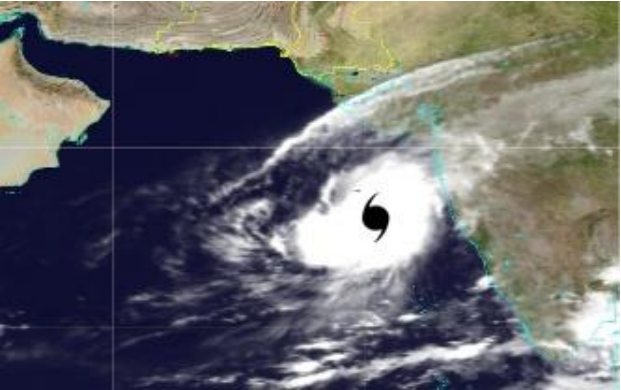
NEW DELHI: Another cyclonic system has started to gain strength near the southern coast of India. The well-marked low-pressure over Maldives-Comorin areas has intensified into a depression on Wednesday morning.
The India Meteorological Department (IMD) has forecast that the system will strengthen further into a cyclonic storm within the next 72 hours.
The low-pressure area, which formed over the equatorial Indian Ocean on Monday, has concentrated into a depression during the early hours of Wednesday. The rapidly intensifying system lies 380 km away from Lakshadweep and is moving northwestwards—towards the Indian coast.
The forecast suggests that the system will further intensify into a deep depression and cross the Lakshadweep islands during the next 24 hours. Heavy rains are forecast across southern India and Lakshadweep during the next two days under the influence of this intensifying system. Many districts in Kerala have been put under an orange alert to be prepared for heavy to very heavy rainfall till Thursday.
A significant number of Nepalis are currently staying and working in different islands of the Maldives at different levels. They have also raised concern over the situation demanding that the government of Nepal initiated immediate efforts to evacuate them at the earliest by making a contingency plan if the situation demands so.
In addition to the southwest coast, the depression will pull moist winds from the Bay of Bengal, enhancing rainfall across the southeastern coast as well. Heavy rain and thunderstorms are likely over Kerala, Karnataka, Rayalseema and Tamil Nadu on Wednesday and Thursday.
Moreover, the IMD has also forecast squally winds with speed reaching up to 60 kmph over Lakshadweep area and up to 50 kmph along the coasts of Kerala and Karnataka till Thursday. As the sea conditions are likely to remain rough to very rough in the region, fishers are warned not to venture into these areas.
The 24-hour rainfall accumulation till Wednesday morning was 82 mm at Minicoy in Lakshadweep.
Light to moderate rainfall is also forecast at most places today, with very heavy falls at isolated places over Lakshadweep and extremely heavy falls on Wednesday and Thursday.
Strong winds clocking 30-40 km/hr and gusting to 50 km/hr may prevail over the Comorin and adjoining Equatorial Indian Ocean and its neighborhood today, the IMD said.
Squally winds with speeds reaching 40-50 km/hr and gusting to 60 km/hr (associated with depression) are forecast over the South-East Arabian Sea and the adjoining Lakshadweep-Maldives areas on Wednesday and Thursday.
The sea condition will be rough to very rough (wave heights of up to 13-20 ft) over the Comorin area and its neighborhood today, and the South-East Arabian Sea and the adjoining Lakshadweep-Maldives areas on both Wednesday and Thursday.
Fishermen have been advised not to venture into the Comorin-Maldives-Lakshadweep areas and the adjoining South-East Arabian Sea on Wednesday and Thursday.
Meanwhile, international forecasters do not have a consensus view of the intensity and track of the projected second depression in the Arabian Sea.
The Canadian Meteorological Centre is the most outspoken of these models, predicting a minimal cyclone heading towards Oman/ Yemen from India’s West Coast
The US Naval Global Environmental Model and the UK Met Office model (see below) show almost identical tracks towards the Gujarat coast – made infamous by very severe cyclone Ockhi of 2017 – for a much weaker system this time around.
While the US Navy model shows no more than a depression traveling along India’s West Coast all the way up to Gujarat, the UK Met Office model suspects a stronger system is there for the asking.
The US Joint Typhoon Warning Centre has located the well-marked low to 574 km to the South of Kochi, with satellite imagery depicting flaring convection (clouding) above a consolidating low-level circulation center.
It assessed that the environment is favorable for further development, given the low vertical wind shear values (up to 27 km/hr) and strong window effect on top.
The vertical wind shear represents the change of wind direction and speed with height, higher values of which can cap storm development by slicing off the head of the building storm tower.
The window effect, or strong upper-level divergence on top, allows the storm to breathe out and keep itself healthy even as the warm waters (up to 30 deg C) provide it ample moisture to feed itself.
The US agency, too, cites the apparent lack of consensus among various weather models with respect to the system credentials – some show a North-ward track along India’s West Coast and turning West towards the Arabian Gulf, as was the case with predecessor supercyclone Kyarr – while others contested it.
Meanwhile, supercyclone Kyarr was located 980 km West of Mumbai, 1,020 km East-North-East of Salalah (Oman) and 510 km East-South-East of Masirah (Oman) early on Tuesday morning.
The IMD expects it to move West-North-West till Wednesday morning, re-curve West-South-West thereafter, and move towards the Gulf of Aden, off the South Oman-Yemen coasts during the subsequent three days.
It is very likely to weaken into an extremely severe cyclone later on Tuesday, a very severe cyclone by tomorrow (Wednesday) and further into a severe cyclone by Thursday morning.
As mentioned already, the IMD has once again underlined its credentials as the best among the storm tracking agencies, by getting it right with supercyclone Kyarr.
In its latest forecast track, even the US Joint Typhoon Warning Centre has plumped for a track that the IMD has stuck with from the word go, i.e. West-North-West initially and later recurving West-South-West into the Gulf of Aden. (Agencies)


Comment