
MYAGDI: Efforts have begun to explore the tourism potential of a largely overlooked watershed area in Dhaulagiri Rural Municipality–2 of Myagdi and to identify and address its key challenges.
A two-day tourism promotion programme, which began on Sunday, aims to highlight the untapped potential of the watershed area while formulating common solutions and coordinating initiatives at the district, provincial and federal levels.
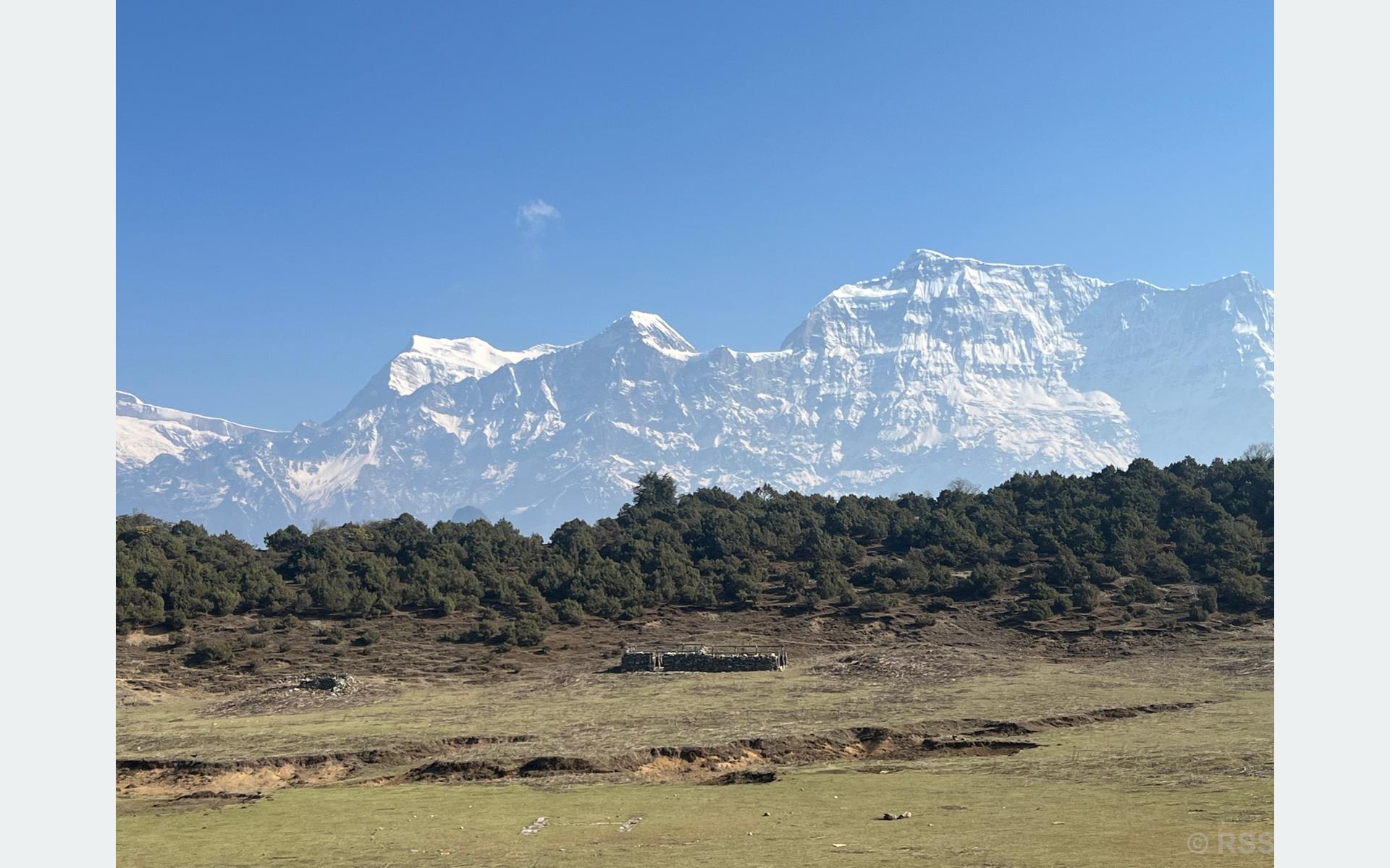
The watershed, located at an altitude of 3,418 metres above sea level and within the Dhorpatan Hunting Reserve, falls under Ward No. 2 of Dhaulagiri Rural Municipality.
Vice-chair of Dhaulagiri Rural Municipality, Resham Pun Magar, said the programme has been organized with participation from elected representatives, private sector stakeholders and local actors to ensure Myagdi benefits from the Dhorpatan region and the watershed area.
He said the initiative aims to draw attention to opportunities created after the opening of the road linking Beni to Taksera in East Rukum via Muna, Khoriya, Mareni, Jaljala and Dhorpatan, while also addressing emerging local challenges.
According to him, a common framework and action plan will be prepared after extensive discussions involving federal and provincial lawmakers, representatives from all six local levels of Myagdi, and stakeholders from neighbouring districts including Baglung and East Rukum.
Participants of the programme reached Jaljala on Sunday afternoon, and the event is scheduled to conclude on Monday with the issuance of the “Jaljala Declaration.”
Jaljala, situated on a plateau in the lap of Gurja, Dhaulagiri, Churen, Putha, and Annapurna ranges, is considered a key viewpoint of the Dhorpatan Hunting Reserve.
Chairperson of Dhaulagiri Rural Municipality, Prem Prasad Pun, said that although around 13 percent of the Dhorpatan Hunting Reserve lies within Myagdi, including monsoon and winter blocks, attention is needed from the federal government to resolve boundary-related issues in areas such as Gurjaghat.
He said the programme also aims to exert pressure for upgrading the 122-kilometre Beni–Taksera road into an alternative route to the Mid-Hill Highway via Baglung, as well as to improve infrastructure for visitors to Jaljala.
According to him, discussions also focus on managing natural resource use in settlements around the hunting reserve and addressing challenges faced by local communities.
Jaljala is known for its open grasslands, changing weather patterns, cool climate and panoramic mountain views. From the site, visitors can observe peaks including Sisne, Putha, Gurja, Dhaulagiri, Nilgiri, Annapurna, Machhapuchhre and Manaslu, along with sunrise views and diverse wildlife.
The area, which lies on a trekking route toward Dolpa via Gurja and Myagdi, currently lacks hotels and permanent settlements. Local resident Phul Bahadur Bik of Lulang has been providing basic accommodation and food services for visitors in a temporary hut.
Typical local foods include wild mushrooms, seasonal greens, dairy products and meat items, while tourists are advised to carry their own camping equipment.
Jaljala is accessible via a roughly one-hour jeep or motorcycle ride from Pakhathar in Dhorpatan, or about two hours from Muna, the administrative centre of Dhaulagiri Rural Municipality. It also requires a five to six-hour trek from either route.


Comment