
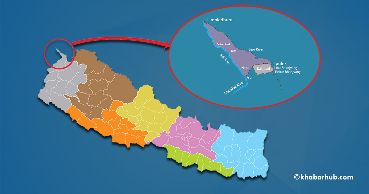
KATHMANDU: Voters from Ward No. 1 of Byas Rural Municipality in Darchula will cast their ballots from the district headquarters Khalanga, as the area they reside in remains beyond the effective control of the Nepali state.
The ward includes Lipulekh, Limpiyadhura and Kalapani, territories incorporated into Nepal’s updated political map in 2020 but currently under Indian administration. Although the government unveiled the revised map through the House of Representatives on May 20, 2020, Nepal has not been able to establish administrative presence in the disputed region.
Following the issuance of the new map, Nepal’s total area increased from 147,181 square kilometers to 147,641.28 square kilometers. However, the territories included in the revised map remain under the control of Indian security forces. Reports indicate that residents in the area have been integrated into the Indian administrative system.
Due to the absence of state presence, Nepal was unable to conduct the 2021 national census in the region. Nevertheless, local representatives of Byas Rural Municipality say around 300 Nepali voters are still listed in Ward No. 1.
“There are around 300 voters in Ward No. 1 of our rural municipality. Arrangements have been made for them to vote from the district headquarters, Khalanga,” a local representative, who requested anonymity, told Khabarhub.
Heavy snowfall during winter months makes the region inaccessible until around mid-April. As a result, residents often migrate to lower areas of India or elsewhere during the colder season. “It is not possible to travel there at this time. Therefore, arrangements have been made for voters to cast their ballots from the district headquarters,” the representative said.
Rajendra Kumar KC, Joint Secretary at the Election Management Division of the Election Commission, had also acknowledged the situation while addressing a program in Kathmandu related to election management.
The dispute intensified after India published a new political map on November 2, 2019, incorporating the broader Kalapani area within its territory. Nepal objected to the move and sent diplomatic notes to India on five occasions, seeking dialogue. However, as talks did not materialize, Nepal proceeded to publish its revised map including Lipulekh, Limpiyadhura and Kalapani.
India has not recognized Nepal’s amended map, calling it a unilateral decision. Since then, movement in and out of Kalapani has become increasingly restricted. However, Nepalis from Chhangru and lower Kawa are occasionally allowed time-bound access to Gunji, Nabi and Kuti for social and cultural purposes such as funerals, marriages and Bratabandha ceremonies.
Military barracks of Indian forces and Indo-Tibetan Border Police are stationed in Kuti, Nabi, Gunji, Tilshe (Kalapani) and Nabidhang. Reports suggest that Nepalis from Tilshe and Nabidhang were driven towards lower Kawa and Chhangru, leaving no permanent Nepali settlement in those areas at present.
India continues to conduct census activities in the region. According to available data, the combined population of Gunji, Nabi and Kuti stands at around 776. Nepal, however, was unable to carry out its 2021 census there.
Historical records show that during the 1961 census, census officer Bhairav Risal, later a noted senior journalist, had deployed enumerators to collect data from Gunji, Nabi and Kuti. At the time, Thir Bahadur Rayamajhi was serving as Superintendent of the Census Department.


Comment