
About 6 kilometers north of Rajbiraj, the administrative center of Saptari district, lie the ruins of an ancient fort. In 1960 AD (2017 B.S.), the then Department of Archaeology conducted explorations across various archaeological, historical, and religious sites throughout the country.
An article titled “Saptari Ko Chandrabhaga Ra Kanchha Khoyira Ka Abasesh Haru” (The Ruins of Chandrabhaga and Kanchha Khoriya of Saptari) was published in the department’s official journal, “Praachin Nepal” (Ancient Nepal), written by Dr. Safalya Amatya, a member of that exploratory team, based on various contextual sources.
Taking the Mahendra Highway route, about 30 kilometers from Lahan (Siraha) lies Kanakpatti village under the Shambhunath Panchayat.
Around 4 kilometers northwest of the village, in the Chure hills, are the ruins of Chandrabhaga Bhagwati and Kanchha Khoriya (fort).
These sites are located approximately 15–16 kilometers southeast of Gaighat, the district headquarters of Udayapur. Situated just northwest of the Khado Khola—a small tributary of the Triyuga River—these ancient sites remain subjects of ongoing exploration and inquiry.
According to local oral traditions, it is believed that a king named Chandraketu ruled this region in the 15th century. He is said to have established the shrine of his family deity, Chandrabhaga Bhagwati, atop the Chure hills, about five kilometers north of Dharmapur village, which lies near the highway in the northeastern part of present-day Saptari district.
So far, genealogies of the Sen kings of Makwanpur do not mention any king named Chandraketu. However, in the Chitaud Sen genealogy, it is recorded that the Sen dynasty began with Chudaraj Sen, and among his 27 descendants is a Sen king named Chandrasen. Mukundasen I is shown as a successor to this Chandrasen.
The fort and palace, located atop a small ridge of the Chure hills, provide easy access to the Tarai region of Ambarpur. It is likely that this site served as a winter palace for the Sen kings of Chaudandi.
If one assumes that Mukundasen I’s father or ancestor Chandrasen is the same as the legendary King Chandraketu mentioned in local folklore, it supports the theory that the Sens entered Nepal from the eastern Tarai region (Makwanpur or Bijaypur).
By the end of the 15th century and the beginning of the 16th century (1482–1520 AD), Mukundasen I, the founder of the Sen dynasty in Nepal, had already established a vast kingdom based in Palpa.
Although there is much debate regarding the exact boundaries of his kingdom, it is evident that after his death (in 1610 B.S.), his four sons—eldest Manikya Sen, second Bhrigi Sen, third Binayak Sen, and youngest Lohang Sen—divided the large Sen kingdom among themselves, which stretched from the Gandaki River in the west to the Teesta River in the east, covering a significant portion of the Tarai region.
Accordingly, the youngest son, Lohang Sen, received the territories he had personally conquered—from Makwanpur to the Koshi region in the east, including the entire eastern Tarai. This kingdom was vast. Later, it was divided into two separate states: Makwanpur and Chaudandi.
After Lohang Sen, his eldest son, Dhabsen, became king of Morang and neighboring regions. Following Raghav Sen, his son Harihar Sen took the throne.
Disputes over succession arose among Harihar Sen’s sons. Due to disagreements with his eldest son, Mahakumar Sen, Harihar Sen divided his kingdom—granting the area west of the Koshi River to his younger son, Shubha Sen, and the region east of the Koshi to his grandson, Induvighata Sen.
Because of the treachery of their own ministers, both Shubha Sen and Induvighata Sen were captured by Nawab Iskandar Khan of Purniya. The Nawab seized a large portion of Morang. Prabodh Das, a loyal follower of Shubha Sen, fled with Shubha Sen’s two sons, Mahipati Sen (also known as Mandhata Sen) and Manik Sen, to seek refuge in the Kirat region.
With the help of the Kirats—especially the Kirati leader Bidyachandra Rai—they succeeded in reclaiming their ancestral kingdom.
Later, Mahipati Sen and Manik Sen divided their ancestral kingdom, with one ruling over Bijaypur and the other over Makwanpur. Whether or not they received assistance from Bidyachandra Rai in this process remains a matter of debate among historians.
There are also differing views regarding the extent of territories governed by Bijaypur and Makwanpur rulers. When Shubha Sen’s kingdom was divided between his two sons, the region stretching from Pouwagadhi of Sindhuli in the hills to the east of the Arun-Koshi River, south of the Sunkoshi River in the Mahabharat range, was organized as a separate administrative unit called the Chaudandi province.
The central Kirat region, between the Dudh Koshi and Arun Koshi rivers, was also incorporated into Chaudandi. A new capital, Chaudandi, was established in the Bhawar region south of present-day Udayapur.
Among Shubha Sen’s two sons, the elder, Mahipati Sen, took control of the Bijaypur region (east of the Kamala River) around 1770 B.S.
The younger son, Manik Sen, established his rule in Makwanpur. Of Manik Sen’s four sons—the eldest Hemkarna Sen, the second Jagat Sen, the third Jayamangala Sen, and the youngest Bikram Sen—Hemkarna Sen succeeded him as king of Makwanpur.
Later, around 1784 B.S., Jagat Sen became the king of Chaudandi. Historians differ on how Jagat Sen came to rule Chaudandi. One version suggests that Jagat Sen initially administered the Chaudandi region as a representative of Hemkarna Sen.
Later, due to disagreements between Hemkarna Sen’s Baniya and Kirati ministers, the Kirati ministers supported Jagat Sen as the king of Chaudandi.
Regardless, in 1835 A.D., the kingdom of Makwanpur was formally divided, with the newly established Chaudandi kingdom including present-day Udayapur district and the lowland Tarai regions of Ambarpur—now parts of Siraha and Saptari districts.
After Jagat Sen, the Chaudandi throne passed successively to his descendants: Mukundasen III, Bikram Sen, and Karna Sen. During the national unification campaign of King Prithvi Narayan Shah, Karna Sen was the reigning monarch of Chaudandi.
To conquer the Chaudandi kingdom, commanders Bhakti Abhiman Singh Basnet and Sardar Parath Bhandari were dispatched. Upon hearing news of the approaching forces of His Majesty King Prithvi Narayan Shah, King Karna Sen fled toward Bijaypur.
As a result, the Sen forces remaining in Chaudandi surrendered and abandoned the capital. Thus, on July 16, 1773, the Sen kingdom of Chaudandi was officially annexed into the greater Kingdom of Nepal.
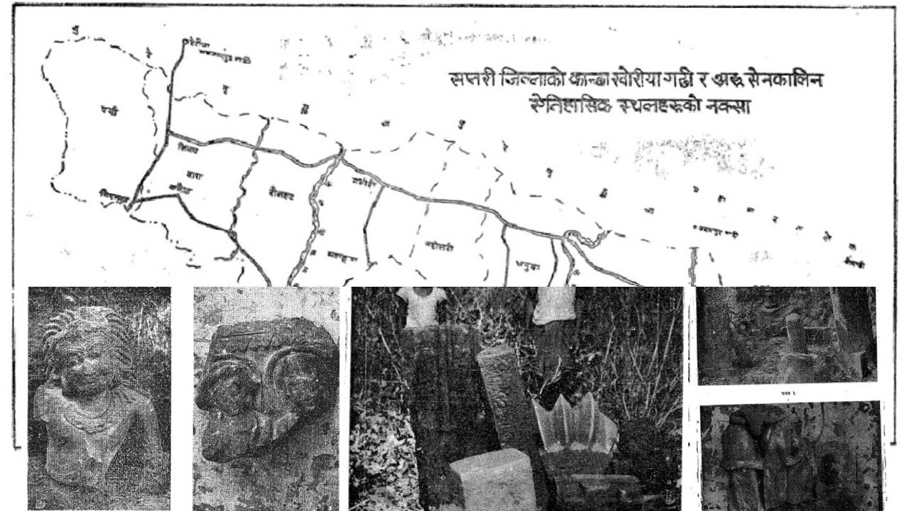
The ruins of Chandrabhaga (Bhagwati) and Kanchha Khoriya (Fort) lie at approximately equal distances from the ancient Sen capitals of Udayapur and Chaudandi Gadhi.
In Kanchha Khoriya, the remains of an ancient palace are visible within a brick-walled fort. To better understand the structure and history of this ancient Sen-era palace, archaeological excavation at the site is necessary.
The famous temple of Shambhunath lies slightly south of the Mahendra Highway, between the villages of Mohanpur and Kanchadaha. Located at the base of the Chure hills, in the plains of the Tarai, the temple is built in Mughal (dome) style.
The remains currently visible on the surface include fragments of brick walls, remnants of a brick-lined well, and some artistically crafted stone fragments. The bricks measure 24 cm in length, 17 cm in width, and 5 cm in thickness.
Unlike most ancient Sen forts, which were built from stone, the brick construction of Kanchha Khoriya fort gives it a distinct historical significance.
The fort and palace, located atop a small ridge of the Chure hills, provide easy access to the Tarai region of Ambarpur. It is likely that this site served as a winter palace for the Sen kings of Chaudandi.
According to Hamilton, several forts were situated within Lohang Sen’s territory—particularly between the Kamala River in the west and the Khado River in the east.
One such fort was noted to be in the Chure hills. It is possible that the fort he referred to as “Churiya Gadhi” or “Nara Gadhi” is, in fact, the present-day Kanchha Khoriya Gadhi.
Even Matrika Prasad Koirala has stated that the old Chatara Gaddi was located southwest across the Koshi River from present-day Chatara.
It is said that the Makwani (Sen) kings first established their seat of power there, which is why the place later came to be known as Gaddi. In their inscriptions (prasastis), the Makwani Sen kings would often include the titles Shri Rupanarayan and others in their royal epithets.
It is believed that these inscriptions are connected to Rupnagar of Saptari, which was likely the original capital of the Makwani Sen dynasty.
Around Rupnagar, areas such as Kanchanpur and Khozarda Cave (which is rumored to house images within the Chure caves) are rich in archaeological materials.
These areas require systematic exploration and investigation. According to Koirala, the old Chatara must have been located somewhere in the Tarai region of Saptari. It is possible that the ruins of Kanchha Khoriya Fort and Palace, located near today’s Shambhunath Panchayat and Dharmapur village, may correspond to the ancient Sen capital Rupnagar.
About two kilometers northwest of the Kanchha Khoriya ruins lies another small ridge of the Chure hills, where the ruins of a temple dedicated to Chandrabhaga Bhagwati can be found.
Many of the temple’s artistic stone fragments appear to have been carried away by the nearby Chandrabhaga River and scattered far across the Tarai plains.
During the winter, an exploration team followed the river route to reach the site and observed many temple fragments along the way. Although the location is known by the name Chandrabhaga Bhagwati, no idol of the goddess or any other deity is currently found there.
The statues and fragments visible today include a Bhairav image, broken stone pillars, likely sculptures of a Sen king and queen, and several Shivalingas.
One of the stone sculptures from this area has now been installed in Rupani Bazaar. However, the face, hands, and feet of the statue are so eroded that they are barely recognizable.
Similar artistic stone fragments can be found scattered around Kanakpatti, particularly in fields and farmlands. These stone artifacts appear to date from around the 15th century AD. A large mela (fair) is held in Shambhunath every year on Baisakh Sankranti (first of the Nepali month of Baisakh).
Locals worship the statue as Hanumanji, but based on its bodily posture and features, it appears to resemble a dancing female figure.
Similarly, it is understood that several other statues from the Chandrabhaga Bhagwati site have been preserved by villagers in Kanakpatti.
Among them, one is said to be a Ganesha statue, though for various reasons, the archaeological team was unable to view it during their exploration.
The famous temple of Shambhunath lies slightly south of the Mahendra Highway, between the villages of Mohanpur and Kanchadaha. Located at the base of the Chure hills, in the plains of the Tarai, the temple is built in Mughal (dome) style.
Inside the temple, an octagonal stone pillar is worshipped as a Shivalinga. This stone pillar is approximately 5 feet 5 inches long. Interestingly, the temple’s main doors face both west and south, which is considered unusual.
It is said that the stone lingam was brought here from the Chandrabhaga River. Along the staircase leading to the temple are scattered fragments of stone carvings, including columns, roof elements, door and arch parts.
Notably, these include a female sculpture (possibly of Mangala Gauri), a torana fragment, a stone piece depicting four-armed Ganesha, and remnants of the temple’s pinnacle (gajur). Also preserved are ancient bricks, measuring 24 cm in length and 17 cm in width.
Similar artistic stone fragments can be found scattered around Kanakpatti, particularly in fields and farmlands. These stone artifacts appear to date from around the 15th century AD. A large mela (fair) is held in Shambhunath every year on Baisakh Sankranti (first of the Nepali month of Baisakh).
Based on the findings of the Department of Archaeology’s exploration team, it is likely that the ruins of Chandrabhaga Bhagwati and Kanchha Khoriya in Saptari represent ancient forts, palaces, and temples dating to the late 15th or early 16th century AD.
(Dr. Amatya, a researcher of Nepalese art, culture, and history, passed away in 2021. This material authored by Amatya has been sourced from Prachin Nepal. Editor.)


Comment