
According to reports, China is planning to build a “super” dam on the lower levels of the Yarlung-Tsangpo River (known as the Brahmaputra in India) along the Line of Actual Control (LAC) in Tibet.
Reports of China’s dam-building activity appear in the media very often, but China never defines the volume and geographical scope of these projects and provides no transparency in the future implications of such projects.
This 60 Gigawatts project close to its heavily militarized frontier with India would supersede its own “Three Gorges Dam”.
More than 130 million people in China, India, and Bangladesh rely on the Brahmaputra River for survival.
China has an ambitious plan that articulates national development goals for the period 2021-2025.
The first 2,840 km of the Brahmaputra River is known as the Yarlung as they meander through Tibet before crossing the Sino-Indian Line of Actual Control, passing through Arunachal Pradesh.
The hydropower sector in China has proposed a gigantic dam at “Great Bend” with a two-kilometer drop over 50 kilometres, for electricity generation despite hydrological obstacles which is an earthquake-prone area.
The “Great Bend dam” would divert water down a tunnel with a 6,562-foot drop, producing twice the power of China’s existing Three Gorges dam.
Symon further claims that satellite imagery reveals that on Chinese side of Line of Actual Control, previous rudimentary positions have given way to an established Chinese presence.
The project called for the construction of a massive tunnel beneath the ridge that separates the two arms of the Big Bend.
China has always insisted that these projects would not impact any of the lower riparian states.
However, as an upper riparian state, China reaps all of the benefits of these transborder river projects.
In total, around 1500 people were killed in the 1950 earthquake.
One shudders to think how many lives a crack in even one of the Big Bend’s nine proposed dams will cost, because the gush of water will destroy every dam downstream and release most of the 50 billion cubic metres or more of stored water into the river valley the-chinese-threat-to-lower-brahmaputra-riparians-india-and-bangladesh/ at the bottom in one gigantic tidal wave.
Furthermore, given China’s recurrent involvement along the Sino-Indian border, the use of water as a weapon is also an issue.
In addition to this reports claim that China plans to divert the river towards the north to mitigate the water scarcity issues in some parts of its country.
According to conservative analysis, China intends to build roughly 100 dams to generate hydropower from main rivers flowing through Tibet.
According to geopolitical researcher Brahma Chellaney, “China is engaged in the greatest water grab in history,” with several dams being constructed on all major rivers flowing off the Tibetan plateau.
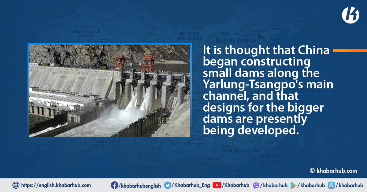
It is thought that China began constructing small dams along the Yarlung-Tsangpo’s main channel, and that designs for the bigger dams are presently being developed.
Geospatial intelligence researcher Damien Symon using satellite data has revealed that one of these smaller dams is being built on the Mabja Zangbo (Tsangpo) river in Tibet’s Burang County, just a few kilometres north of the Indian-Nepali-Chinese border trijunction.
China maintains that their infrastructure is not intended to suck water from the river; however, a report claims that it is not valid.
The river will have a series of breaks spanning 10-100 km between a “point of diversion” to the turbines and a “point of return” of water to the river.
Any such project by China must involve all riparian nations to avoid future conflicts and the need for stricter international laws concerning all nations.
Symon further claims that satellite imagery reveals that on Chinese side of Line of Actual Control, previous rudimentary positions have given way to an established Chinese presence.
This further proofs of China’s intentions in causing continuous instability along sections of the Himalayan border.
China’s recent increased military presence and infrastructure construction in disputed Himalayan areas, as well as the use of lethal force in border clashes with Indian troops in November 2022, all demonstrate Beijing’s willingness to take risks in relations with India to pursue other goals.
In accordance with customary International law 1968 Helsinki Rules and 1997 UN Convention on Non-Navigational uses of International Watercorses, India being a lower riparian cannot veto interventions in a river by the upper riparian but can ask for prior notice of intention of intervention, full detailed technical intervention due regard for the concerns of the lower riparian, advance consultations and the acceptance of the principle of avoidance of ‘substantial harm’ or ‘significant injury’ to the lower riparian.
Looking at past interactions between both countries China would hardly be concerned to provide such details to India.
Any such project by China must involve all riparian nations to avoid future conflicts and the need for stricter international laws concerning all nations.


Comment