
KAVREPALANCHOWK: Travel on the BP Highway has been challenging for the past one and a half years. In recent days, the highway has been blocked multiple times due to moderate and light rains, and it was blocked twice by March end.
Once a key route facilitating travel through the mid-hills, the highway was permanently reconstructed with an expected completion timeline of two years.
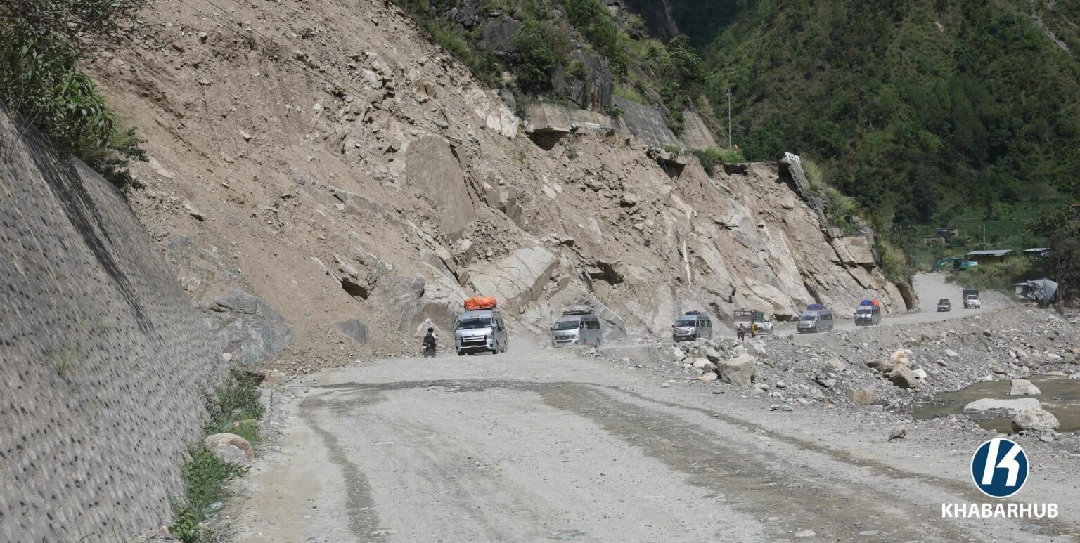
The BP Highway is the shortest, most important alternative connecting Kathmandu with eastern Nepal. Floods and landslides—especially in the section from Chowkidanda in Kavrepalanchowk to areas in Sindhuli—have made travel unsafe. The middle section toward Kavrepalanchok has collapsed, been washed away, and damaged, severing road connectivity in multiple places.
While parts of the highway were damaged during the rainy season, floods in the Roshi River during consecutive months of September last year and this year caused extensive damage. Sections of the highway became impassable even for pedestrians. Although temporary roads and diversions were constructed, permanent reconstruction has been necessary.
Initial inspections by the Division Road Office, Bhaktapur, revealed that about four kilometers of road had been washed away, requiring a diversion from the river to restore access.
However, traders have reportedly influenced authorities to allow vehicles up to 25 tons, particularly tippers transporting gravel and sand. These heavy vehicles are a major factor in damaging the highway’s structure. More than 600 tippers operate daily on this route, often exceeding their capacity.
Completed in sections at a cost of about 26 billion Japanese yen, the BP Highway provides a direct connection between Kathmandu and eastern Nepal, eliminating the need to travel via the longer Narayanghat–Muglin route.
Last year, incessant rains on Asho 10–12 damaged 10 kilometers of road from Bardibas to Dhulikhel. Temporary repairs allowed partial use, but further rains in last September caused additional damage.
This highway, which begins from Dhulikhel along the Araniko Highway, is also linked to the under-construction Pushpalal National Highway. Sections already weakened by the earthquake suffered further damage from floods and landslides in 2024–2025.
Unbridged rivers such as Bhyakure, Ghyampe, and Roshi have repeatedly caused closures during heavy rains. Floods last year damaged around 30 kilometers of the road from Bhakundebensi in Kavrepalanchok to Nepalthok in Sindhuli. Several areas, including Nepalthok–Aaptar, Kaldhunga, Dalabensi, Chiuribas, and Bridge No. 1, suffered extensive washouts, destroying temporary diversions as well.
Road sections at Narke Bazaar, Chowkidanda, Daunne, Mamti Khola, and Besi were completely washed away. Even temporary tracks were destroyed during the last week of Baisakh, necessitating repeated repairs.
The Division Road Office, Bhaktapur, has now accelerated permanent reconstruction on three damaged sections of the highway. Senior Divisional Engineer Suman Yogesh said the work is being sped up so that infrastructure in high-risk areas can be completed before the next rainy season, allowing vehicles to operate safely.
He added that 25% of the work has been completed so far, and reconstruction is expected to be finished within two years.
Permanent reconstruction began last December, following flood and landslide damage in September 2024 and this year’s rains. Contracts for reconstructing 3.2 kilometers from Barkhekhola to Piple under the Japan International Cooperation Agency (JICA) will be signed this month.
Work has begun on installing RCC walls at damaged sites, including Chowkidanda, Charsayabeshi, and Bhakundebeshi. The road is being widened in sections from Dalabeshi to Mangalatar and from Charsayabeshi to Narke, with designs aimed at making the highway resistant to future floods.
The government aims to complete the reconstruction of damaged sections of the BP Highway in Kavrepalanchok and Sindhuli within the next two years. Work has begun simultaneously on three sections of the highway, with plans to complete road widening and structural construction in damaged areas this year.
Next year, reconstruction will accelerate with additional structural work and blacktopping in remaining sections. Landslides have previously damaged about 30 kilometers of road in these areas.
The highway will be upgraded to a two-lane road, and several bridges will be expanded to accommodate increased traffic. Senior Divisional Engineer Suman Yogesh stated that additional bridges will be constructed alongside existing ones to make them two-lane, and five bridges in total are planned for conversion.
Contracts for the reconstruction have been awarded to several construction firms. The 8.5-kilometer road from Dalabesi to Charsayabesi has been assigned to Khani-Avon-Kamaljit JV at a cost of Rs 1.4237 billion, including VAT.
The 11.8-kilometer section from Charsayabesi to Bhakundebesi will be rebuilt by Lama-Nawakantipur JV at Rs 1.3353 billion, while the 4.9-kilometer road from Nepalthok to Barkhekhola has been contracted to Kharidhunga-Ghising-Kshitij JV for Rs 610 million, including VAT.
Out of the total 29.5 kilometers of damaged road, a grant of Rs 2.63 billion from the Japan International Cooperation Agency (JICA) will fund the reconstruction of the 3.2-kilometer Barkhekhola to Piple section.
The government has already allocated Rs 8.5 billion for other sections, with Rs 7.5 billion for three road sections toward Kavrepalanchok and Rs 1 billion for a section in Sindhuli. Work on temporary arrangements for traffic has already begun after detailed monitoring and inspections.
Continuous rain last year caused significant damage to the Bhakundebesi–Nepalthok section of the highway. According to Engineer Bindu Adhikari, the Roshi River damaged 17 points along the route, with high-risk areas including Chowkidanda, Boksekuna, Mamti, Charsayabesi, and Ghumaune. Reconstruction in these areas will start from scratch.
Currently, traffic is operating on 110 kilometers of the highway, while 50 kilometers remain under reconstruction. The reconstruction process for the 29-kilometer section damaged by last year’s floods and landslides has been divided into four sections. During the floods, eight kilometers of road were completely washed away, making extensive rebuilding necessary.
The highway remains a critical short route connecting the federal capital, Kathmandu, with the mid-hills and eastern Nepal, providing an essential alternative to longer routes through the region.
During the permanent reconstruction of the damaged highway, it is planned that at least two vehicles will be able to pass simultaneously on the intermediate lane, which will have a seven-meter-wide blacktop.
Additionally, another road will be constructed with an RCC wall below the river level, designed to remain operational even during floods in the Roshi River. In the first phase, the office plans to make the 28-kilometer stretch from Bhakundebesi to Nepalthok a two-lane road.
Due to the ongoing risk on the highway, vehicle movement has frequently been banned, especially at night. Around 3,000 vehicles travel on the highway daily, but during festivals, traffic can triple. According to technical studies conducted by JICA, vehicles weighing more than 16 tons should not operate on the BP Highway.
However, traders have reportedly influenced authorities to allow vehicles up to 25 tons, particularly tippers transporting gravel and sand. These heavy vehicles are a major factor in damaging the highway’s structure. More than 600 tippers operate daily on this route, often exceeding their capacity.
While occasional police checks are conducted, there is no consistent monitoring, allowing some operators to bypass regulations and put the highway at risk.
The District Traffic Police Office, Kavrepalanchok, reports that over 3,000 vehicles, both small and large, currently ply the BP Highway each day. Due to obstructions on the Muglin–Narayangadh road section, most smaller vehicles coming from the east are diverted via BP Highway. The road is primarily used by tippers, minibuses, Tata Sumos, and microbuses.
The BP Highway, a 160-kilometer route from Dhulikhel to Sindhuli and Bardibas, was constructed in sections beginning in the fiscal year 2053/54 BS with grant assistance from the Japanese government. It was formally handed over to the Government of Nepal by Japan.
The highway remains a critical short route connecting the federal capital, Kathmandu, with the mid-hills and eastern Nepal, providing an essential alternative to longer routes through the region.


Comment