
KATHMANDU: The government has declared 59 local levels across 18 districts as disaster areas due to the extensive damage caused by floods and landslides following the recent incessant rains.
However, the specifics regarding which municipalities are affected have yet to be disclosed, leaving many of the declared municipalities unaware of their crisis status.
During a Council of Ministers meeting, ministers recognized the devastation in these local levels, which were impacted by heavy rainfall.
The National Disaster Risk Reduction and Management Authority Executive Committee recommended that the government categorize the most affected districts as disaster-prone areas.
Confusion surrounds the number of municipalities officially designated as being in crisis.
Government spokesperson Prithvi Subba Gurung announced that various local levels in 12 districts had been declared in crisis.
Conversely, Home Minister Ramesh Lekhak stated that 41 local levels in 14 districts were affected.
This discrepancy led to reports claiming that 41 districts were declared crisis-hit.
However, documents held by the Chief Secretary confirm that the actual number is 59 local levels across 18 districts, consistent with the recommendations from the authority.
When asked about the specific municipalities affected, a source from the National Disaster Risk Reduction Authority stated, “We sent a message to the government to declare 59 municipalities in 18 districts as crisis zones, and the decision has been made according to our proposal. A formal circular may be issued once the Chief Secretary signs it.”
Why is a crisis area declared?
Section 32 of the Disaster Risk Reduction and Management Act 2074 empowers the government to declare specific local levels as disaster zones.
According to the Act, “If it is deemed necessary to declare a disaster-prone area due to the occurrence of a disaster of a serious nature in any part of Nepal, the Government of Nepal can declare the area as a disaster-prone area by publishing a notice in the Nepal Gazette, specifying the boundaries and duration of such area.”
The Council of Ministers has designated these 59 local levels as crisis areas for a period of three months, with the possibility of extending this duration if necessary.
The law allows for the temporary closure of government, non-government offices, and educational institutions in the designated areas if deemed essential.
Furthermore, the Act mandates that rescue and relief efforts be prioritized in crisis areas and outlines restrictions on actions that may hinder such efforts.
The government is also authorized to assign employees to assist in these regions.
Reconstruction efforts will be prioritized in the local levels declared as crisis areas due to the disasters that struck the 18 affected districts as a result of the recent floods and inundation.
Which municipalities are in crisis?
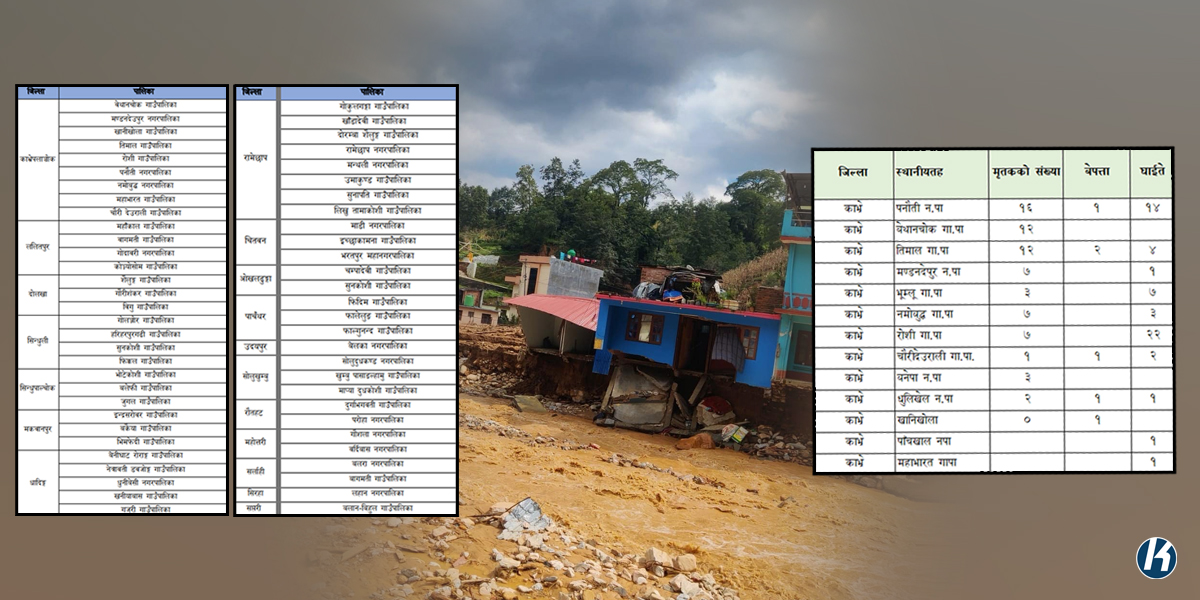
According to government statistics, Kavrepalanchowk and Ramechhap have witnessed the most significant damage due to heavy rainfall.
The government has declared 9 municipalities in Kavrepalanchowk and 8 municipalities in Ramechhap as crisis zones.
Additionally, 5 municipalities in Dhading have been designated as crisis areas, along with 4 local levels each in Lalitpur and Sindhuli.
Moreover, 3 local levels in Sindhupalchowk, Dolakha, Makwanpur, Chitwan, Panchthar, and Solukhumbu have been declared crisis areas.
Two municipalities each in Okhaldhunga, Rautahat, Mahottari, and Sarlahi are also affected.
Belka Municipality in Udaypur, Lahan Municipality in Siraha, and Balan-Bihul Rural Municipality in Saptari have also been designated as crisis areas.
Kavrepalanchowk
The government has declared 9 local levels in Kavrepalanchowk as crisis areas, including 3 municipalities and 6 rural villages.
The affected municipalities include Mandandeupur, Panauti, and Namobuddha, while rural municipalities such as Bethanchowk, Khanikhola, Timal, Roshi, Mahabharat, and Chauri Deurali are also included.
Ramechhap
Ramechhap, significantly impacted by flooding, has had 8 local levels declared as crisis areas.
This includes Ramechhap and Manthali municipalities, along with Doramba, Shailung, Umakunda, Sunapati, Likhu Tamakoshi, Gokulganga, and Khandadevi Rural Municipality.
Dhading
Following Kavrepalanchowk and Ramechhap, Dhading is another district with multiple municipalities declared as crisis areas.
The Council of Ministers has identified 5 municipalities: Benighat Rorang, Netravati Dawjong, Khaniyabas, Gajuri, and Dhunibeshi. Of these, Dhunibeshi is a municipality, while the others are village councils.
Lalitpur
In Lalitpur, Mahankal, Bagmati, and Konjyosom rural municipalities, along with Godavari Municipality, are included in the list of crisis areas.
Dolakha
Dolakha has had Shailung, Gourishankar, and Bhigu Rural Municipality declared as disaster-prone areas.
Sindhuli
The affected areas in Sindhuli include Golanjor Rural Municipality, Hariharpurgarhi Rural Municipality, Sunkoshi Rural Municipality, and Fikkal Rural Municipality.
Sindhupalchowk
Bhotekoshi, Balefi, and Jugal rural municipalities in Sindhupalchok have also been designated as crisis areas.
Makwanpur
In Makwanpur, Indrasarovar, Bakaiya, and Bhimfedi rural municipalities are listed among the crisis areas.
Chitwan
Chitwan includes Bharatpur Metropolitan Municipality, Madi Municipality, and Ichchakamana Rural Municipality among its distressed areas.
Okhaldhunga
Okhaldhunga has declared two rural villages, Champadevi and Sunkoshi, as disaster-prone areas due to flooding.
Panchthar
Fidim, Phalelung, and Falgunanda Rural Municipality in Panchthar have also been declared as crisis areas.
Solukhumbu
The government has declared three local levels in Solukhumbu, known for being home to Mount Everest, as crisis areas.
This includes Soldudhakunda Municipality, along with the rural areas of Khumbu Pasanglhamu and Mapya Dudhkoshi.
Rautahat: Durgabhagavati Rural Municipality and Paroha Municipality are identified as affected areas in Rautahat.
Mahottari: The municipalities of Gaushala and Bardibas in Mahottari have also been declared as distressed areas.
Sarlahi: Balara Municipality and Bagmati Rural Municipality in Sarlahi are included in the list of crisis areas.
Udaypur: Belka Municipality has been designated as a crisis zone.
Siraha: Lahan Municipality is declared as a crisis area.
Saptari: Balan-Bihul Rural Municipality has also been included in the list of affected areas.
Why was Kathmandu not declared a crisis zone?
Despite the declaration of 59 local levels across 18 districts as crisis zones, Kathmandu Metropolitan City, the federal capital, has not been included in the government’s list.
This is surprising given the significant damage caused by floods and landslides, which impacted many residents in Kathmandu.
Dr. Dijan Bhattarai, spokesperson for the Disaster Risk Reduction and Management Authority, explained that the crisis area was not declared for Kathmandu because rescue operations are easier in urban areas.
“Declaring the federal capital as a crisis zone could send a negative message to the international community,” he told Khabarhub.
In Udaypur, Sirha, and Saptari, only one municipality each has been declared a crisis zone: Belka Municipality in Udaypur, Lahan Municipality in Siraha, and Balan-Bihul Rural Municipality in Saptari.
Dr. Bhattarai noted that the Authority has recommended acknowledging the loss of life and damage caused by the disaster at the local level.
He indicated that the Authority had advised the government to declare 59 local levels in 18 districts as disaster-prone areas, which the cabinet subsequently approved.
Casualties from recent floods and landslides
Kavre (70 fatalities): A total of 70 people have died across 10 local levels in Kavre district due to flash floods.
Lalitpur (45 fatalities): Lalitpur follows Kavre in terms of human losses, with 45 reported fatalities.
Kathmandu (18 fatalities): Despite not being officially declared a disaster area, Kathmandu district has recorded 18 deaths.
Other Districts: In Dhading, three people have died in Gajuri, and one each in Thakre and Jamalukhi Rural Municipalities.
In Makwanpur’s Indrasarovar, six fatalities were reported, while Solukhumbu’s Dudhkund Nagarpalika saw five deaths. Additionally, five people died due to landslides in Lisankhupakhar Rural Municipality, Sindhupalchok.
Summary of casualties
Total Fatalities: 246 people have died across various districts due to landslides and flooding following three days of continuous rain. According to Nepal Police, 18 individuals remain missing.
Injuries and Rescues: The police report indicates that 178 people were injured, and 17,174 individuals were rescued from the floods and landslides.
In the Kathmandu Valley alone, 70 people have died, 7 are missing, 37 were injured, and 2,158 were rescued.
Provincial Breakdown:
Koshi Province: 20 fatalities
Madhesh Province: 9 fatalities
Bagmati Province: 139 fatalities
Lumbini Province: 2 fatalities


Comment