
KATHMANDU: After remaining in limbo for 23 years, the long-awaited Outer Ring Road project around Kathmandu Valley is finally gaining momentum. The government has initiated new efforts to construct a 550-meter-wide ring road that will encircle the valley from the Kantha area.
The Kathmandu Valley Development Authority (KVDA) has proposed starting with the Chobhar–Satungal section in the first phase under a revised development model.
According to Project Chief Subhash Basnet, preparations are underway to build the road using the guided land development model, as the previous land pooling approach has proven unworkable.
“Since the government adopted the land pooling model in 2001, nothing significant has materialized. If that approach were feasible, the road would have been completed within the past 23 years,” Basnet said. “We are now preparing to proceed as per Section 10 of the Kathmandu Valley Development Authority Act, 2045.”
Basnet further stated that in Ashad last year, the KVDA held consultations with mayors and ward chairpersons from Chandragiri and Kirtipur municipalities regarding the proposed 6.6-kilometer-long and 50-meter-wide Chobhar–Satungal section. The local governments have responded positively to the new proposal.
Basnet pointed out that the current land pooling model has been the main obstacle preventing progress on the Outer Ring Road. “If we continue with the same model, we won’t see results even in 100 years,” he warned. “We now need a policy-level decision from the Council of Ministers to adopt the guided land development model.”
He added that the KVDA plans to hold one more round of discussions with local stakeholders before Dashain and then seek approval from the federal government. “Our primary concern now is whether the government will greenlight this concept or not,” Basnet said.
If approved, the KVDA aims to complete the Outer Ring Road within four years. The Chobhar–Satungal section is considered vital due to its commercial and logistical importance. This stretch also serves as a connector for the Kathmandu–Terai/Madhes Expressway and links the Chobhar dry port to Thankot.
Approximately 250 houses will need to be demolished in a 1.5-kilometer portion of this section. Compensation for these structures is estimated to account for about 1% of the total project cost. To avoid delays, the KVDA is preparing to cover the compensation expenses upfront.
Basnet emphasized that this model would result in a “win-win” situation for both the government and landowners. “People often say that houses have already been built along the road boundary, so how will the Outer Ring Road be constructed? That’s a misconception. The guided land development approach is built on mutual benefit, and it presents a far more practical solution.”
What is the Guided Land Development Concept?
Before understanding the KVDA’s new approach, it’s essential to contrast it with the existing land pooling model.
Land Pooling Model: In this model, fragmented urban plots are pooling and redeveloped in a planned way. Infrastructure like roads, drainage, water supply, schools, parks, and open spaces is developed, and the landowners receive smaller but organized plots with full access to these services. However, landowners are required to surrender a percentage of their land to the government for these public facilities.
This model faced a major setback after a 2075 BS decision by the Council of Ministers, which removed the term “land acquisition” from project reports under the Land Acquisition Act, 2034 BS. As a result, project files became stuck in the Ministry of Urban Development, and construction plans, including the Chobhar–Satungal section, were halted.
Guided Land Development: In contrast, the guided land development concept proposed by KVDA allows for more flexible land use and planning, where landowners and the government jointly benefit without extensive acquisition. It encourages voluntary land readjustment, minimizes forced acquisition, and expedites infrastructure development with less public resistance.
Basnet is confident that the new model will help revive the stalled Outer Ring Road project, ensure compensation isn’t a bottleneck, and ultimately bring progress to a project long seen as a symbol of inaction.
Guided Land Development
The guided land development concept offers a fresh alternative to traditional land pooling methods, aiming to develop unorganized settlements and urban areas at minimal cost.
Unlike the conventional land pooling approach—where the government directly intervenes to replot land and develop infrastructure—the guided model empowers local bodies or the government to outline the basic infrastructure layout. Landowners or private developers then carry out the development under specific guidelines.
“The state doesn’t need to spend large sums upfront. Individuals contribute to development, and in return, everyone benefits from organized housing and long-term infrastructure,” said Subhash Basnet, Project Chief of the Kathmandu Valley Development Authority (KVDA).
According to KVDA, this model is far more flexible. Unlike the older approach, it doesn’t require repeated permissions from the Council of Ministers. Once a single approval is secured, implementation can proceed either through user committees or the private sector in collaboration with the authority.
“That’s why it’s often called a shortcut to land development,” Basnet added. “Work that used to drag on for generations can now be completed within four years. If we succeed with the Chobhar–Satungal section, the remaining stretches will be even faster.”
Scope of the first phase
The Chobhar–Satungal section will involve around 9,000 ropanis of land, of which 600 ropanis belong to the government. Additionally, about 450 ropanis (5%) of open space is available, which can be used for public structures or community services. Currently, the KVDA is awaiting central government approval to move forward with this plan.
In this model, landowners will need to contribute between 20% and 40% of their land to the project. Even after developing infrastructure, approximately 27–28% (around 2,400 ropanis) of land will remain. If sold at a minimum rate of Rs 2.5 million per ropani, the project could generate Rs 9.6 billion for the government. These funds can be reinvested into further infrastructure development.
Basnet noted that the guided land development model has been in practice in Nepal since 2045 BS, particularly for road expansion projects, and has had a success rate of up to 90%.
“The government has allocated Rs 1.5 million for the current fiscal year and Rs 2 million in the previous year. Most of that was used for salaries,” Basnet said. “If the government commits to the financial resources required for road expansion, we will ensure there are no delays. That’s the ‘sweet secret’ of this new modality.”
So far, the government has invested about Rs 134 million in the Outer Ring Road project.
Why the Outer Ring Road is urgent
The Kathmandu Valley’s population is increasing rapidly. In 2068 BS, it stood at 1.7 million; by 2078 BS, it had surged to 2.41 million. With more people migrating to the Valley for work, education, and other opportunities, vehicle traffic has grown significantly, straining existing infrastructure.
Recognizing this, the government initiated a feasibility study for the Outer Ring Road in 2058 BS, with budget allocations beginning in 2061/62 BS. However, only 54.47% of the proposed 72-kilometer road has been studied to date, and little real construction has taken place.
Expert Opinions: Too little, too late?
Road transport expert Ashish Gajurel believes the Outer Ring Road is vital to easing congestion in the Valley.
“This road should have been built immediately after its announcement to manage Kathmandu’s traffic. But progress has been painfully slow, and no real effort has been made to ensure its success,” Gajurel said.
Bheshraj Lohani, outgoing president of the Nepal Land and Housing Development Federation, echoed similar concerns.
“After the project was announced, there was a surge in land transactions in the area, often involving collusion between officials and land traders for quick profits,” Lohani said.
“Now, as the government delays implementation, residential settlements are rapidly filling up the proposed road corridors. The longer the delay, the more complicated the situation becomes.”
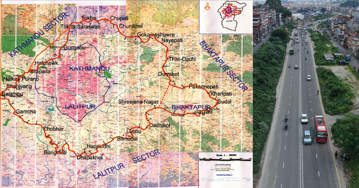
Progress so far
A 72-kilometer, eight-lane Outer Ring Road has been proposed to encircle the Kathmandu Valley, covering all three districts: Kathmandu, Bhaktapur, and Lalitpur. Of the total length, 33.98 kilometers will fall within Kathmandu, 18.612 kilometers in Bhaktapur, and 13.99 kilometers in Lalitpur.
In Kathmandu, the Detailed Project Report (DPR) has already been completed for several key sections. These include the Chobhar–Satungal section (6.6 kilometers), completed in the fiscal year 2064/65; the Satungal–Paiyatar section (10.92 kilometers) in 2067/68; the Paiyatar–Khadka Bhadrakali section (6 kilometers) in 2070/71; and the Sundol–Nayapati–Thalidachhi section (3.96 kilometers), also completed in 2064/65. However, the DPR for the Khadka Bhadrakali–Sandol section, which spans 6.5 kilometers, remains incomplete.
In Bhaktapur district, the DPR has been completed for the Araniko Highway–Dadhikot–Sirutar section (3.5 kilometers), as well as the Thalidachhi–Bhatedhikuro section (9.512 kilometers), both completed in 2064/65. However, the Bhatedhikuro–Araniko Highway–Naya Thimi section (5.6 kilometers) still lacks a DPR.
In Lalitpur, the DPR for the Lubhu–Harisiddhi section (5 kilometers) was completed in 2062/63, while the Harisiddhi–Khokana section (8.99 kilometers) was finalized in 2066/67.
According to a feasibility study conducted in 2078 BS, the Kathmandu Valley Development Authority estimated that compensation for structures and land acquisition on the roughly 9,000 ropanis of land in the first phase would require around Rs 1 billion. For the full 72-kilometer road, which could require the acquisition of between 80,000 and 100,000 ropanis, the total compensation cost is estimated at Rs 72 billion.


Comment